Map Frame
The map frame of an axesm-based map is the
outline of the limits of a map, often in the form of a box, the
"edge of the world," so to speak. The frame is displayed if the
axesm-based map property Frame is set to
'on'. This can be accomplished upon
axesm-based map creation with axesm, or later
with setm, or with the direct command framem on.
The frame is geographically defined as a latitude-longitude quadrangle that is projected
appropriately. For example, on a map of the world, the frame might extend from pole to
pole and a full 360° range of longitude. In appearance, the frame would take on the
characteristic shape of the projection. The examples below are full-world frames shown
in four very different projections.
Full-World Map Frames
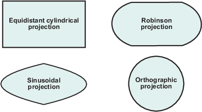
As a map object, each of the previously displayed frames is identical; however, the selection of a display projection has varied their appearance.
You can manipulate properties beyond the latitude and longitude limits of the frame.
Frame properties are established upon axesm-based map object
creation; you can modify them subsequently with the setm and the
framem functions. The command framem alone
is a toggle for the Frame property, which controls the visibility
of the frame. You can also call framem with property names and
values to alter the appearance of the frame:
framem('FlineWidth',4,'FEdgeColor','red')
The frame is actually a patch with a default face color set to
'none' and a default edge color of black. You can alter these
axesm-based map properties by manipulating the
FFaceColor and FEdgeColor properties. For
example, the command
setm(gca,'FFaceColor','cyan')
makes the background region of your display resemble water. Since the frame patch is
always the lowest layer of a map display, other patches, perhaps representing land, will
appear above the "water." If an object is subsequently plotted "below" the frame patch,
the frame altitude can be recalculated to lie below this object with the command
framem reset. The frame is replaced and not reprojected.
Set the line width of the edge, which is 2 points by default, using the
FLineWidth property.
The primary advantage of displaying the map frame is that it can provide positional context for other displayed map objects. For example, when vector data of the coasts is displayed, the frame provides the "edge" of the world.
See the framem reference page for more
details.