WebMapServer
Web map server
Description
A WebMapServer object represents a Web Map Service (WMS)
and acts as a proxy to a WMS server.
The WebMapServer object resides physically on the client side. The
object can access the capabilities document on the WMS server and perform requests to
obtain maps. It supports multiple WMS versions and negotiates with the server
automatically to use the highest known version that the server can support.
Creation
Description
server = WebMapServer(serverURL) creates a
WebMapServer object, setting the
ServerURL property.
Properties
Object Functions
getCapabilities | Get capabilities document from server |
getMap | Get raster map from server |
updateLayers | Update layer properties |
Examples
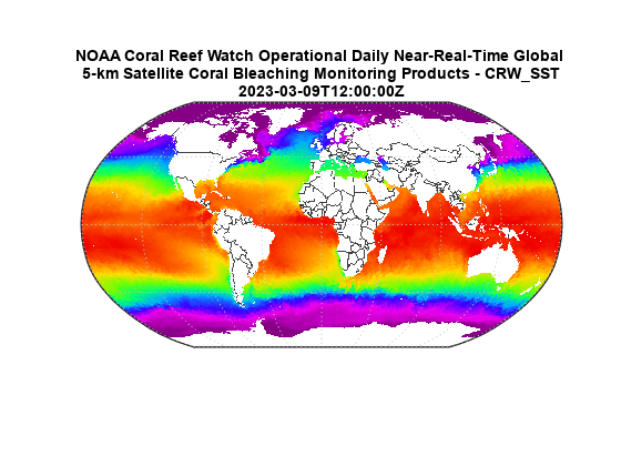
Construct a WebMapServer object that communicates with one of the Environmental Research Division's Data Access Program (ERDDAP) WMS servers hosted by NOAA. Obtain the capabilities document from the server.
layers = wmsfind("NOAA_DHW",SearchField="serverurl");
serverURL = layers(1).ServerURL;
server = WebMapServer(serverURL);
capabilities = getCapabilities(server);
layers = capabilities.Layer;
Search for a server that shows nation boundaries (nations). Search for a server that provides daily, global sea surface temperature (sst) data.
nations = refine(layers,"nations");
nations = nations(1);
sst = refine(layers,"sst");
sst = sst(1);
layer = [sst nations];
Obtain the data from the servers.
request = WMSMapRequest(layer,server);
A = getMap(server,request.RequestURL);
R = request.RasterReference;
Display the data on a map.
figure
worldmap(A,R)
geoshow(A,R)
plabel off
mlabel off

layerTitle = string(sst.LayerTitle);
layerTitle = textwrap(layerTitle,65);
layerTitle = [layerTitle; sst.Details.Dimension.Default];
title(layerTitle,Interpreter="none")
Version History
Introduced before R2006a