ortho
Orthographic Projection
Classification
Azimuthal
Identifier
ortho
Graticule
The graticule described is for a polar aspect.
Meridians: Equally spaced straight lines intersecting at the central pole. The angles displayed are the true angles between meridians.
Parallels: Unequally spaced circles centered on the central pole. Spacing decreases away from this pole. The opposite hemisphere cannot be shown.
Pole: The central pole is a point; the other pole is not shown.
Symmetry: About any meridian.
Features
This is a perspective projection on a plane tangent at the center point from an infinite distance (that is, orthogonally). The center point is a pole in the common polar aspect, but can be any point. This projection has two significant properties. It looks like a globe, providing views of the Earth resembling those seen from outer space. Additionally, all great and small circles are either straight lines or elliptical arcs on this projection. Scale is true only at the center point and is constant in the circumferential direction along any circle having the center point as its center. Distortion increases rapidly away from the center point, the only place that is distortion-free. This projection is neither conformal nor equal-area.
Parallels
There are no standard parallels for azimuthal projections.
Remarks
This projection appears to have been developed by the Egyptians and Greeks by the second century B.C.
This implementation of the orthographic projection is applicable only for coordinates that are referenced to a sphere. If you want to project coordinates that are referenced to an ellipsoid, using the
projfwdorprojinvfunctions, then create aprojcrsobject instead of a map projection structure. You can create aprojcrsobject for the orthographic projection using the ESRI authority code 102037. For example:projcrs(102037,'Authority','ESRI').Mapping Toolbox™ uses a different implementation of the orthographic projection for displaying coordinates on
axesm-based maps than for projecting coordinates using theprojfwdorprojinvfunction. These implementations may produce differing results.
Limitations
Data greater than 89º distant from the center point is trimmed.
Example
landareas = shaperead('landareas.shp','UseGeoCoords',true);
axesm ('ortho', 'Frame', 'on', 'Grid', 'on');
geoshow(landareas,'FaceColor',[1 1 .5],'EdgeColor',[.6 .6 .6]);
tissot;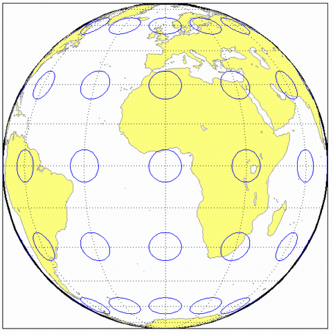
Version History
Introduced before R2006a