MapPostingsReference
Reference raster postings to map coordinates
Description
For a 2-D raster of posting point samples, a
MapPostingsReference object describes the relationship between the
intrinsic coordinate system for the raster
and a planar coordinate system. The object associates each element of the raster with a
location in planar coordinates.
A MapPostingsReference object assumes that the raster is sampled
regularly in the world xy-coordinates of the map system. The sample
spacing from row to row does not need to equal the sample spacing from column to
column.
The intrinsic and world coordinate systems have a rectilinear relationship when the axes of the intrinsic and world coordinate systems align. The coordinate systems have a affine relationship when the intrinsic axes are rotated with respect to the world axes. An affine relationship allows for rotation and skew.
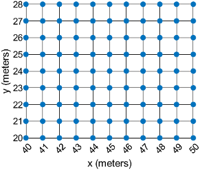
This image illustrates a 9-by-11 raster of postings in planar coordinates. The postings are spaced 1 meter apart in x and y, cover x values in the range [40,50] in meters, and cover y values in the range [20,28] in meters. The boundary of the raster of postings is a rectangle with edges that pass through the outermost postings.
To reference a raster of cells to planar map coordinates, use a MapCellsReference object instead.
Creation
You can use these functions to create MapPostingsReference
objects:
readgeoraster— Import a raster data file as an array and a reference object.maprefpostings— Create a map raster reference object by specifying the x and y world limits of the raster and either the size of the raster or the spacing of the postings.maprasterref— Convert a world file to a map raster reference object.refmatToMapRasterReference— Convert a referencing matrix to a map raster reference object.
Properties
Object Functions
contains | Determine if geographic or map raster contains points |
cropToBlock | Crop raster reference object to row and column limits of raster |
firstCornerX | Return world x-coordinate of map raster index (1,1) |
firstCornerY | Return world y-coordinate of map raster index (1,1) |
intrinsicToWorld | Transform intrinsic to planar world coordinates |
sizesMatch | Determine if geographic or map raster object and image or raster are size-compatible |
worldFileMatrix | Return world file parameters for transformation |
worldGrid | World coordinates of raster elements |
worldToDiscrete | Convert planar world coordinates to discrete subscripts |
worldToIntrinsic | Transform planar world to intrinsic coordinates |
Examples
Import elevation data as an array and a MapPostingsReference object. Then, display the data on a map.
For this example, specify the file to import by extracting a GZ file into a temporary directory. Then, set the name of the first extracted file to a variable.
filenames = gunzip("sanfranciscos.dem.gz",tempdir);
filename1 = filenames{1};
Import the data by using the readgeoraster function. Prepare the data for plotting by specifying the output type as "double".
[Z,R] = readgeoraster(filename1,OutputType="double");View the properties of the MapPostingsReference object.
R
R =
  MapPostingsReference with properties:

             XWorldLimits: [544050 555150]
             YWorldLimits: [4164120 4178070]
               RasterSize: [466 371]
     RasterInterpretation: 'postings'
         ColumnsStartFrom: 'north'
            RowsStartFrom: 'west'
    SampleSpacingInWorldX: 30
    SampleSpacingInWorldY: 30
     RasterExtentInWorldX: 11100
     RasterExtentInWorldY: 13950
         XIntrinsicLimits: [1 371]
         YIntrinsicLimits: [1 466]
       TransformationType: 'rectilinear'
     CoordinateSystemType: 'planar'
             ProjectedCRS: [1×1 projcrs]
Display the elevation data as a surface on a map. Apply a colormap that is appropriate for elevation data.
mapshow(Z,R,DisplayType="surface")
demcmap(Z)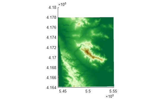
More About
Version History
Introduced in R2013b