Scenario Generation and Visualization
Generate satellite scenarios to model and visualize satellites in orbit and to perform additional analyses such as computing access with ground stations.
Objects
satelliteScenario | Satellite scenario |
satelliteScenarioViewer | Create viewer for satellite scenario |
Satellite | Satellite in satellite scenario |
Platform | Platform in satellite scenario (Since R2024a) |
GroundStation | Ground station object belonging to satellite scenario |
ConicalSensor | Conical sensor object belonging to satellite scenario |
GroundTrack | Ground track object belonging to satellite or platform in scenario |
Transmitter | Transmitter object belonging to satellite scenario |
Receiver | Receiver object belonging to satellite scenario |
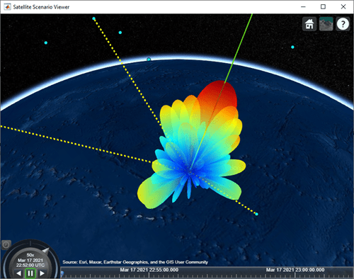
Pattern | Radiation pattern visualization (Since R2021b) |
Gimbal | Gimbal object belonging to satellite scenario |
Access | Access analysis object belonging to scenario |
FieldOfView | Field of view object belonging to satellite scenario |
Link | Link analysis object belonging to Transmitter |
Orbit | Orbit visualization satellite object (Since R2024a) |
geoTrajectory | Waypoint trajectory in geodetic coordinates (Since R2024a) |
quaternion | Create quaternion array (Since R2024a) |
Functions
Topics
- Satellite Scenario Basics
Build complete satellite scenario simulation.
- Satellite Scenario Key Concepts
Learn common satellite scenario visualization terms.
Featured Examples
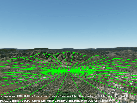
Satellite Visibility Analysis Using Terrain
Analyze satellite visibility from a ground station using a visibility mask computed from the surrounding terrain. A visibility mask is a set of azimuth and elevation angles that define where obstructions block a satellite's line-of-sight visibility.

Coverage Maps for Satellite Constellation
Display coverage maps for a region of interest using a
satelliteScenario and 2-D maps.

Aircraft-to-Satellite Communication for ADS-B Out
Examine ADS-B Out connectivity of a flight.

Analyze NTN Coverage and Capacity for LEO Mega-Constellation
Analyze coverage and capacity of a very low population density region for LEO mega-constellation for satellite-based NTN applications.

Multi-Hop Satellite Communications Link Between Two Ground Stations
Set up multi-hop link between two ground stations.

Satellite Constellation Access to Ground Station
Set up access analysis between a ground station and conical sensors onboard a constellation of satellites.

Comparison of Orbit Propagators
Compare the orbits predicted by the Two-Body-Keplerian, SGP4, and SDP4 orbit propagators.

Calculate Latency and Doppler in a Satellite Scenario
Model and calculate the latency and Doppler frequencies between the satellite and the ground station.

Modeling Satellite Constellations Using Ephemeris Data
Add time-stamped ephemeris data for a constellation of satellites to a satellite scenario for access analysis.
Interference from Satellite Constellation on Communications Link
Analyze interference on a downlink from a constellation of satellites.

Estimate GNSS Receiver Position with Simulated Satellite Constellations
Track the position of a ground vehicle using a simulated Global Navigation Satellite System (GNSS) receiver.

Multi-Hop Path Selection Through Large Satellite Constellation
Select the multi-hop path through large satellite constellation to gain access between two ground stations.

Modeling Custom Satellite Attitude and Gimbal Steering
Point satellite or gimbal in satellite scenario using logged orientation data from
timetable or timeseries.

Location-Based Analysis of Visible GPS Satellites
Analyze the visible GPS satellites from a particular location using
satelliteScenario.

Iridium Satellite Spot Beam Coverage on the US
Generate and visualize Iridium satellite spot beams on the US map.