mappolyshape
Description
A mappolyshape object represents a polygon or multipolygon in
planar coordinates. A polygon is a region bounded by a closed curve and
can include interior holes. A multipolygon is an individual polygon
shape that includes multiple nonintersecting regions.
Polygons and multipolygons are useful for defining areas of interest (AOIs). For more information about AOIs, see Define Areas of Interest.
To represent a polygon or multipolygon in geographic coordinates, use a geopolyshape object
instead.
Creation
To create mappolyshape objects, either:
Import polygon data in planar coordinates as a geospatial table using the
readgeotablefunction, and then query theShapevariable of the table.Create a rectangular AOI by using the
aoiquadfunction.Create an AOI of circles by using the
aoicirclefunction.Use the
mappolyshapefunction (described here).
Description
shape = mappolyshape(
creates a x,y)mappolyshape object or array of mappolyshape
objects with vertices at the specified x- and
y-coordinates. The sizes of x,
y, and the mappolyshape object array
shape match.
The mappolyshape function assumes that x and
y define polygons with valid topology. A polygon has valid topology when:
Region interiors are to the right as you trace boundaries from vertex to vertex.
The boundaries have no self-intersections.
In general, the outer boundaries of polygons with valid topology have vertices in clockwise order and the interior holes have vertices in counterclockwise order.
Input Arguments
Properties
Object Functions
Examples
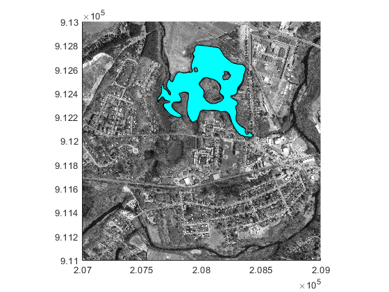
Import a shapefile containing hydrographic data for Concord, MA as a geospatial table. The shapefile represents the data using polygons.
hydro = readgeotable("concord_hydro_area.shp");Create a subtable that contains a polygon representing a pond. Get information about the polygon by querying the Shape variable of the table.
pond = hydro(14,:);
pond.Shape
ans =
  mappolyshape with properties:

              NumRegions: 1
                NumHoles: 3
                Geometry: "polygon"
    CoordinateSystemType: "planar"
            ProjectedCRS: [1×1 projcrs]
Import an orthophoto of Concord, MA, along with a map cells reference object and a colormap. Display the orthophoto and polygon on a map.
[ortho,R,cmap] = readgeoraster("concord_ortho_w.tif");
mapshow(ortho,cmap,R)
mapshow(pond,FaceColor="c")
Create an individual polygon with no holes as a mappolyshape scalar. Specify the projected CRS as World Equidistant Cylindrical, which has the EPSG authority code 4087.
x = [-113 -49 -100 -113];
y = [39 45 19 39];
polyshp = mappolyshape(x,y);

p = projcrs(4087);
polyshp.ProjectedCRS = p
polyshp =
  mappolyshape with properties:

              NumRegions: 1
                NumHoles: 0
                Geometry: "polygon"
    CoordinateSystemType: "planar"
            ProjectedCRS: [1×1 projcrs]
Create a multipolygon with two regions and one hole as a mappolyshape scalar.
x = [69 90 105 79 69 NaN 6 52 43 14 6 NaN 18 32 22 18];
y = [37 46 31 20 37 NaN 45 49 35 32 45 NaN 35 40 42 35];
multipolygon = mappolyshape(x,y);
multipolygon.ProjectedCRS = p
multipolygon =
  mappolyshape with properties:

              NumRegions: 2
                NumHoles: 1
                Geometry: "polygon"
    CoordinateSystemType: "planar"
            ProjectedCRS: [1×1 projcrs]
Create two individual polygons as a 1-by-2 mappolyshape array. The second polygon contains a hole.
x = {[69 90 105 79 69],[6 52 43 14 6 NaN 18 32 22 18]};
y = {[37 46 31 20 37],[45 49 35 32 45 NaN 35 40 42 35]};
polyArray = mappolyshape(x,y);
polyArray.ProjectedCRS = ppolyArray=1×2 mappolyshape array with properties:
NumRegions: [1 1]
NumHoles: [0 1]
Geometry: "polygon"
CoordinateSystemType: "planar"
ProjectedCRS: [1×1 projcrs]
Version History
Introduced in R2021b